Real Time Kinematic
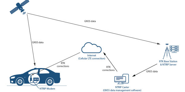
RTK also known as Real time Kinematic. It is a technology that uses a base station and a mobile rover receiver to achieve centimeter level accuracy for location based tasks. It corrects errors that occur in standard gps signals. Instead of depending only on a single GPS receiver, RTK uses two receivers, a base station and a rover. The base station sits in a known position and sends correction data to the rover in real time. This continuous flow of corrections removes signal noise and atmospheric physical changes, giving incredibly accurate location data.
How RTK Works with GNSS?

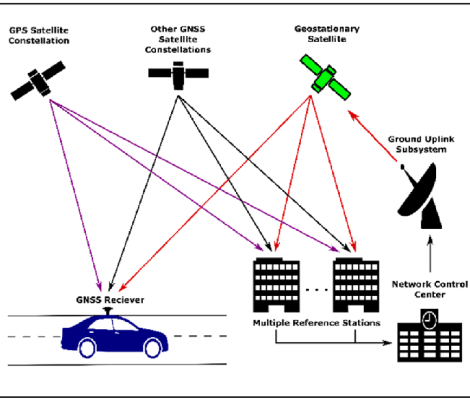
RTK works on top of Global Navigation Satellite System signals also known as GNSS. GNSS provides the raw satellite data, while RTK enhances it.
Signal reception
Both receivers collect GNSS signals from multiple groups such as GPS, Galileo, and BeiDou.
Error comparison
The base station calculates the difference between its known position and the satellite data it receives.
Real time corrections
It transmits these differences to the rover, which adjusts its own position instantly.
Why Accuracy Matters for Autonomous Systems?
An autonomous car cannot itself afford to guess its position. Even a half meter error could shift a vehicle out of its lane or cause it to drift from its ongoing path. That’s why RTK GNSS has become a foundational technology.
Consistent lane-level positioning
even in dense urban or industrial areas.
Reliable data for decision-making algorithms
allowing AI systems to react faster and more safely.
Stability across environments
from open highways to tunnels and ports.
By combining RTK corrections with other sensor cameras, navigation systems achieve redundancy and resilience against signal dropouts.
RTK vs. Traditional GPS
Traditional GPS receivers can locate a device within three to ten meters. That’s fine for phones or mapping apps but not for machines that move autonomously.
RTK technology refines that margin dramatically. Using dual-frequency GNSS signals and real-time correction data, RTK narrows positioning error to less than two centimeters under clear conditions. This improvement translates directly into higher reliability and safety for any system depending on navigation data.
Key Benefits of Real-Time Kinematic Positioning

Superior Precision
RTK delivers centimeter level accuracy, providing detailed mapping, automated steering, and perfect landings
Increased Efficiency
With correct data, autonomous systems spend less time correcting and wasting no time performing productive tasks.
Lower Operational Risk
Accurate positioning prevents collisions and reduces error-based downtime in high-value operations.
Scalable Integration
RTK modules can be built into, survey devices, or entire vehicle fleets, making large-scale automation easier.
Real-Time Performance
Corrections are instant, no waiting for post processing or manual adjustment.
Industrial and Commercial Applications
Agriculture
Tractors which are equipped with RTK GNSS, plants and harvest with less overlap saving more fuel and seed.
Construction
Survey teams are using RTK to map sites and guide heavy equipment with accuracy that eliminates rework again and again.
Autonomous Vehicles
Lane keeping and obstacle avoidance require RTK precision combined with sensor fusion.
Maritime Navigation
RTK helps ships dock safely and manage automated port operations easily.
Role in Advancing RTK Simulation
Engineers use simulation to make RTK more robust before deployment.
The Autonomous Vehicle Training Simulator replay real world conditions such as signal interference, weather effects, and multipath reflections. By simulating these challenges, ZATNAV helps developers fine tune RTK algorithms without risking real equipment.
Applying RTK into simulation environments ensures that autonomous systems can handle both ideal and imperfect conditions from open skies to dense cityscapes.
Explore ZATNAV’s Autonomous Vehicle Training Simulator →
Challenges in Real-World Implementation
No doubt that RTK is powerful but it still faces some challenges
Signal Obstruction
Block line of sight can be caused by tall buildings and trees.
Communication Reliability
Correction data must be in flow continuously without stopping.
Base Station Availability
Local reference stations are needed for maximum accuracy.
The Future of RTK and GNSS Integration
Next upcoming generation systems will combine RTK with AI powered error modeling. Machine learning can predict signal degradation and automatically switch to alternative correction sources.
With 5G fast connection, RTK data can travel faster than ever supporting live fleet tracking, proper agriculture, and automated delivery vehicles.
By 2030, centimeter accurate navigation will be standard in commercial transport and logistics, unlocking full autonomy across industries.
Conclusion
Accuracy defines success and achievement. Real-Time Kinematic GNSS is the clear winner.
It sharpens positioning, enhances safety, and enables intelligent navigation in a world moving toward autonomy.
Through advanced simulation and research, ZATNAV ensures that the future of navigation is not just smart, but precise.
To learn more about how RTK powers your next autonomous project, visit ZATNAV.com.
